


History

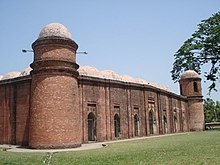
Ruins at Puthia, Rajshahi
Economy

Padma River flows beside Rajshahi City
- Varendra Research Museum
- Shrine of Hazrat Shah Makhdum Ruposh (R). It is located besides the river Padma, in the Dargah Para of the city. The name Dargah Para is derived from the word Dargah which means shrine and refers to the shrine of Hazrat Shah Makhdum Ruposh (R).
- Bara Kuthi (16th century Dutch establishment)
- Temple of King Kangsa Narayan
- Shona Dighi (Golden Pond)
In spite of being an important city and located on a riverbank, industrial development in Rajshahi has not taken place to any great extent. Locals have claimed that this is due to lack of attention from the central government in Dhaka. In the 60's an Industrial Park had been established in Rajshahi, which is now mainly home to industries producing products of the famous Rajshahi silk. Rajshahi is also home to a jute mill, a sugar mill and mango based industries.There will be rapid industrial development in Rajshahi if gas is supplied through pipeline which the people of Rajshahi have been demanding for a long time. The government has taken steps to supply gas to Rajshahi quickly and a project towards this end has already begun.
It was recently declared that Rajshahi will be the first "Digital City" in the country though what this description implies is still unclear.
Transport
Transportation in Rajshahi is very good. Rajshahi is connected to the rest of country through roads, rail and water. Unfortunately no air transportation is presently in operation in Rajshahi.Road Transport
It takes about 5 to 6 hours by road to reach the capital, Dhaka from Rajshahi. A number of bus services including air-conditioned and non-air conditioned buses are available from and to Dhaka. Bus services to other major districts are also available from the Bus Terminal of Rajshahi.Railway

The New Rajshahi Railway Station
From Rajshahi:
At 7:15 am Silk City and at 4:00 pm Padma Express
From Dhaka:
At 3:12 pm(Airport)Silk City and at 11:45 pm (Dhaka Cantonment)Padma Express.
There are also a number of intercity express trains which runs between Rajshahi and other major cities of Bangladesh.
Shah Makhdum Airport

Shah Makhdum Airport, Rajshahi
Some important information on Shah Makhdum Airport, Rajshahi:
- Airport Code : VGRJ IATA: RJH
- Runway Length : 6000/100 ft.
- Runway Elevation: 55 ft (17 m).
- Longitude : 88° 36' 59E
- Latitude : 24° 26' 14N
- World Area Code : 703
Heritage
Rajshahi is famous for its characteristic sweetmeats, not to be found anywhere else in the country. These special preparations include Roshkodom, Khaja, Raghobshahi and Kachagolla (Natore is specially famous for this particular sweetmeat). Along with neighboring Chapai Nababganj, Rajshahi is the home of the regions best mangoes and lichis. Rajshahi is also the home of Barendra Museum which is famous for its collection of local sculpture and other artifacts dating from medieval times, and of Rajshahi silk, the finest silk produced in Bangladesh.Major Places
Shrine of Hazrat Shah Mokhdum (Rh.)
A Majar or Dorga (Shrine) is established around the grave of Hazrat Shah Mokhdum Ruposh (Rh.) at Dargahpara in Rajshahi city. It is said that Hazrat Shah Mokhdum Ruposh (Rh.) was the first Islam preacher in the Rajshahi region. It is also said that he came to Rajshahi through the river Padma riding on a crocodile. Even now, some crocodiles are reserved in the Dighi (Large Pond) next to the shrine of Hazrat Shah Mokhdum (Rh.).Dargahpara
Dargahpara is famous for the shrine of Hazrat Shah Mokhdum Ruposh (Rh.) and for the large bank of river Padma.Two famous educational institute,Rajshahi Govt.College and Rajshahi Collegiate School, are also situated in this area.There is also another shrine of Shah Turkan (Rh.) which is older than the shrine of Hazrat Shah Mokhdum Ruposh (Rh.).Varendra Research Museum

Varendra Research Museum
It was one of the first non government initiatives for building a museum by some enlightened people with Kumar Sarat Kumar Roy during the British era. This museum has a large collection of statues of Lord Surya and some unique masterpieces illustrating the history of the locality and its civilization.
Bangladesh Railway
The headquarter of Bangladesh Railway (Western Zone) is in Rajshahi. Rajshahi Railway Station is being modified and developed to house more passengers and to offer more services to the city dwellers.Bangladesh Betar
Bangladesh Betar (Radio Bangladesh) has a regional station in Rajshahi which transmits various programs of mass interest. Rajshahi station has a broadcasting house and transmitters in different locations. Two transmitters of 100 kW and 10 kW transmitting capacity transmit the programs developed at the broadcasting house. The Rajshahi station transmits its programs in Medium Wavelength. The popularity of the radio is low in Rajshahi like other places of Bangladesh because of the low quality programmes of Bangladesh Betar.Radio Foorti
Radio Foorti has started its regional FM station in Rajshahi from 2010. The station transmits its Broadcasting on 88.00 MHz from the Rajshahi studio. The station airs 24 hour everyday. The station is getting increasingly popular to the young generation in very short period of time. The station broadcasts very high quality programs and music round the clock.Bangladesh Television
Bangladesh Television, commonly known as BTV, is the national television channel of Bangladesh. It has a relay center in Rajshahi city.Central Park and Zoo

Rajshahi Central Park
Rajshahi Zoo
Baliapukur
Its situated between the Rajshahi University of Engineering & Technology (RUET) and The Bus Terminal. A residential area, Padma Housing State has also been established beside this area. It is one of the largest but less well planned residential areas in Rajshahi.Borokuthi
In the compound of the Barakuthi there is a small cemetery with groves dating back to the years of the nineteenth century. There are 14 tombs with thirteen epitaphs within the cemetery. Here also some natureral calimetari which make people enjoy for time being.Bulonpur
The district and divisional offices, the civil and criminal courts are situated in this particular area.ChottoBongram
Chottobongram is the largest area in Rajshahi. There are two Children parks, Bonghobondhu College, Highway Road & 7 great masjids etc. It boasts of having a large mango and lychee garden. It has become a nice professional residential area with a unique communal and academic atmosphere that makes it one of the most desirable residential locations in the city.BoroBongram
This is a large are on the northern region of Rajshahi city just north of Chhoto Bonogram. Rajshahi city is developing along its northern side and BoroBonogram is going to be the heart of New Rajshahi city in near future. Noudapara is the main market place of BoroBonogram and is situated beside the crossing of Rajshahi bypass road and Airport road. The crossing is well known by the name 'Aam Chottor' as large concrete mango remics (like silk, mango is also the symbol of Rajshahi) have been built and placed at the center of the crossing.There also a Disable people organization, this name is Protibondhi sawnirvor sangstha (PSS). this office address:Nowdapara sahid zia shishu park more. here also a computer training center. this name is sahar banu computer training center. There is a big islamic madrasa and mazar sharif of Hazrat Shah Mukhtari, named Khankah Sharif at Borobongram. The bus terminal of Rajshahi is shifting here in a large space.Laxmipur
The Board of Intermediate and Secondary Education, the Laboratory High School, the New Government Degree College, Teachers' Training College, Rajshahi Government Medical College and Hospital and the Varendra Research Museum are located in this area. Another institute called Institute of Health Technology (IHT) situated here. It is one of the three government institute of health technology.this part are arbaniged by mohajer from India during the rule of Murshid kuli Khan that its name was Mahadi pur.Kazihata
Kazihata is a small part of the town but quite known for the presence of quite a lot of government & private institutions like Bangladesh Bank, Radio Bangladesh, TV studio (non functional), Christian mission hospital, House building finance corporation, Soil Research Institute and others.The people Kazihata is proud of are famous singer Andrew Kishor many eminent teachers Professor Dr. Golam Shabbir Sattar (Tapu). Professor Nurullah, cricketers, hockey players & professionals like doctor, engineer & lawyers. This days kazihata becomes more important area. It can called vip area also. Because of most famous teachers and professors of Rajshahi are living in this area. As Sopon kumar, Nitto gopal and many more. The famous government laboratory high school, Model school and college are also part of Kazihata. It will be probably the future commercial area of rajshahi
Shaheb Bazar
The municipal office, Rajshahi Collegiate School, Rajshahi College, Masjid Mission Academy, Loknath school, Deaf and Mental schools are located here. The Shaheb Bazar mosque is situated just on the junction of the Natore road with Shaheb Bazar Road. Here also an ancient Establishment called Amir Ali Avenue which is under a waquf state called Salamot miya waquf state. which is engaged in various social work before 50 year.The old municipality building is also situated here by the side of an old pond Named Sona Dighi (gold pond).Kadirgonj
It is one of the oldest place in Rajshahi. It situated besides Shaheb Bazar. Rajshahi City Corporation is situated in that place.Shahid Kamrujjaman lived here. Many people come here to see their respct on him. One Gov. collage & some Gov. and Private schoole are situate here.Uposhahar

Mango round about
Motihar
Motihar is nearly declared thana under Rajshahi city corporation. Some parts of Charghat Thana is also included in its area. The Rajshahi University is situated here on large campus surrounded by mango groves that presents a panoramic view.Kazla, Talaimari
Two prestigious and renowned public universities, the University of Rajshahi (established in 1953) and the Rajshahi University of Engineering & Technology (RUET - established in 1964 as BIT, Bangladesh Institute of Technology and in 2002 it became the University) are located in Kazla-Talaimari area. Rajshahi is called the Educational Capital of Bangladesh and these two are the major educational institutions here in Rajshahi. Keeping pace with, peripheral campuses of several private universities have also been established in this area of Rajshahi city.Sopura

Old hindu temple at Sopura, Rajshahi
Shiroil
is the famous place in Rajshahi for the Railway Station and the old Bus Terminal. "Shiroil Govt. High School, Rajshahi" is located here.Harian
Harian, a place few Kilometers away from the city, is famous for a sugar mill which was established by B.I.D.C. It has been founded by the great initiative of the Mridha Family, a renowned family of the locality. Late Mamtaz Uddin Mridha, the then Chairman of the Harian Union Parishad, was one of the leading persons to make this history happened.There is also a rail station, some high schools and primary schools are here.
Horagram Bajar
Horagram, a place few km to the west side, is famous for mango archerd. Rajshahi court is in here. A rail station is also here.Educational institutions

Administrative building of Rajshahi University

Shabash Bangladesh, a sculpture commemorating the liberation war.

Rajshahi College, One of the famous educational Institutes of Rajshahi
- Rajshahi University Web: www.ru.ac.bd
- Rajshahi University of Engineering & Technology
- Rajshahi College
- Asian University of Bangladesh,Rajshahi Campus
- Rajshahi Medical College Has Bangla Forum: www.rmcforum.com
- Islami Bank Medical College, Rajshahi
- Rajshahi New Govt. Degree College
- Barendra College
- Shah Mokhdum College
- Rajshahi City College
- Rajshahi Cadet College
- Rajshahi Polytechnique Institute
- Teacher's Training College
- Shahid Mamun Mahamud High School & College(police line)
- Rajshahi Collegiate School
- Government Madrasa High School Rajshahi
- Government Laboratory High School Rajshahi
- Shiroil Govt. High School, Rajshahi
- P.N. Govt. Girls School
- Rajshahi University School And College
- Rajshahi Loknath High School
- Masjid Mission Academy, Rajshahi
- Rajshahi Muslim High School
- Rajshahi High Madrasa
- Sarda Police Academy
- Postal Academy of Bangladesh
- Rajshahi Model School and college
- River View High School, Rajshahi
- Rajshahi Mohila polytechnique Institute
- Agarani school & college
- Paramount School and College (English-Medium)
- International Hifjul Quraan Academy
- Shardah Government Pilot High School
- Shahid Najmul Huq Girls' High School
- Bangladesh polytechnique Institute
- Adarsho karigori & Banijjik college, Hatemkhan, Rajshahi-6000.
- Adarsho T.T. College, Rajshahi
- Jamiah Darul Uswah, Shahmokhdum R/A, Sopura, Rajshahi;
| ? | What is expected from workers? |
You must be member of DigitalPoint.com Forum (http://forums.digitalpoint.com). I want you to pick 1 Free eBook from my site www.indigitalworks.com and post it on DigitalPoint forum under Cheap/Free stuff category.
1. Login on your DigitalPoint forum account
2. Go to the "Cheap Stuff“ category (here's shortcut: http://forums.digitalpoint.com/forumdisplay.php?f=105)
3. Pick 1 random product (not the first one) from one of the following categories on my site:
http://www.indigitalworks.com/EBooks-with-Resell-Rights-Silver-Membership/
http://www.indigitalworks.com/Software-with-Master-Resell-Rights-Silver-Membership/
http://www.indigitalworks.com/EBooks-with-Master-Resell-Rights-Silver-Membership/
http://www.indigitalworks.com/Software-with-Giveaway-Rights-Silver-Membership/
http://www.indigitalworks.com/EBooks-with-Private-Label-Rights-Silver-Membership/
4. Create a new thread describing the product (20-30 words) and include a link to the product. Remember, this is a free product and you can feature/offer him like that
Important:
Do not copy-paste the existing product description in thread. You must write your own. Anchor text of the link should be the title of a product. For example, if the name of a product is “RSS software” then you should use this as an anchor text for a link.
| ! | Required proof that task was finished? |
1. Your forum Username
2. URL of your post
2. URL of your post