

St. Martin's Island '(Bengali: সেন্টমার্টিন দ্বীপ) is a small island in the northeast of the bay of bengal, about 9 km south of the Cox's Bazar-Teknaf peninsular tip and forming the southernmost part of Bangladesh. It is about 8 km west of the northwest coast of Myanmar at the mouth of the river naf.
The island is 7.315 km long and is aligned NNW and SSE. Geographically, it is divided into three parts. The northern part is called Narikel Jinjira or Uttarpara and is 2,134m long and 1,402m wide. The southern part is known as Dakshinpara, which is 1,929m long, with a narrow tail of 1,890m towards the southeast, and a maximum width of 975m. A narrow central belt or Maddhyapara connects the two parts. The length and the width of this belt are about 1,524m and 518m respectively and the narrowest collar is known as Golachipa. In addition to the main island there are a number of tiny islets ranging from 100 to 500 sq m which are locally known as Chheradia or Siradia which means separated island.
There is a shallow lagoon in the middle of Uttarpara and it is connected to the sea during high tide by a narrow channel on the western coast. The topsoil of Uttarpara consists of alluvial sands mixed with shells of molluscs. There are two small dead lagoons and a stretch of marshy land in Dakshinpara. Fish landing sites, bazars and schools are present only in Uttarpara.
Launches and country boats ply between the island and teknaf regularly. The population is about 3,700 and most of them are fishermen belonging to 535 families. One hundred eighty-two species of wildlife are recorded from the island. Of these, 4 species are amphibians, 28 reptiles, 130 birds and 20 mammals. tourism to the northern part of the island exists during four months (November to February). The most densely populated part is Jinjira. There is scarcity of sweet water on the island. Only a few ponds and a number of tubewells supply sweet water for drinking as well as for cultivation. Though the island falls in the monsoon zone, the climate is much influenced by the sea. The main vegetation is coconut, betel nut and bamboo. Coconut trees are abundant and more concentrated in the Jinjira area. The soil of the island is not so fertile. The main agricultural products are onion, watermelon and some rice.
The geological structure of the island is simple and is represented by an anticlinal uplift. A little of the axis of the anticline is traceable along the west coast of Dakshinpara. The exposed portion of the axis runs NNW to SSE, approximately parallel to the island. There is a fault along the northwestern shoreline with a trend nearly parallel to the axis. St Martin's limestone is composed of molluscan coquina horizons (shelly limestone) and coral clusters (coralline limestones). Being very porous and permeable, the shelly limestone provides an excellent aquifer wherever they occur beneath the alluvium. Recent marine sands and the shelly limestone are the chief source of fresh water.
Several living small coral colonies are found in small sheltered pools very near the low tide level around the island. They also occur in the surrounding shallow sea, mostly growing on the beach rocks and calcareous sandstone concretions. The dead coral colonies also occur in pool-like depressions within the high and low tide levels. Some of them are located at an elevation of nearly 3.50m above the low tide level. The oldest fossil coral belongs to Late Pleistocene, giving an age of 33,238 years (C14 dating). The clearest indication of the Holocene upliftment of the island is the appearance of an emerged 3.0m coquina limestone cliff on the coast of Dakshinpara ranging in age from 450 years at the base to 292 years at the top (C14 dating). The mean uplifting rate of the island, calculated from the above data, is 19.0 mm/year. The location of the cliff is 1.5m above the present high tide level and on the eastern upthrown faulted block.
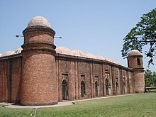
Sixty Dome Mosque in Mosque city of Bagerhat was built in the 15th century and is the largest historical mosque in Bangladesh, as well as a World Heritage site.
History of Bangladesh
Since independence, the government has experienced periods of democratic and military rule. The founding leader of the country and its first president was Sheikh Mujibur Rahman. His daughter Sheikh Hasina Wazed is currently the prime minister, as leader of the Awami League. The opposition Bangladesh Nationalist Party is led by Begum Khaleda Zia, who is the widow of the revered freedom fighter and former president Ziaur Rahman.
Pre-historic Bengal
Stone tools provide the earliest evidence of human settlements. Prehistoric stone implements have been discovered in various parts of West Bengal in the districts of Midnapur, Bankura and Burdwan. But it is difficult to determine, even approximately, the time when people using them first settled in Bengal. It might have taken place ten thousand years (or even more) ago. The original settlers spoke non-Aryan languages—they may have spoken Austric or Austro-Asiatic languages like the languages of the present-day Kola, Bhil, Santal, Shabara and Pulinda peoples. At a subsequent age, peoples speaking languages from two other language families—Dravidian and Tibeto-Burman—seem to have settled in Bengal. Archaeological discoveries during the 1960s furnished evidence of a degree of civilisation in certain parts of Bengal as far back as the beginning of the first millennium BC, perhaps even earlier. The discoveries at Pandu Rajar Dhibi in the valley of the Ajay River (near Bolpur) in Burdwan district and in several other sites on the Ajay, Kunar and Kopai Rivers have thrown fresh light on Bengal's prehistory. Pandu Rajar Dhibi represents the ruins of a trading township, which carried on trade not only with the interior regions of India, but also—possibly indirectly—with the countries of the Mediterranean.Bengal in mythology
Some references indicate that the early people in Bengal were different in ethnicity and culture from the Vedic beyond the boundary of Aryandom and who were classed as 'Dasyus'. The Bhagavata Purana classes them as sinful people while Dharmasutra of Bodhayana prescribes expiatory rites after a journey among the Pundras and Vangas. Mahabharata speaks of Paundraka Vasudeva who was lord of the Pundrasand who allied himself with Jarasandha against Krishna. Mahabharata also speaks of Bengali kings called Chitrasena and Sanudrasena who were defeated by Bhima, Kalidas mentions Raghu defeated a coalition of Vanga kings who were defeated by Raghu and Raghu established a victory column in the Gangetic delta.Proto-History

Mahasthangarh is the oldest archaeological site in Bangladesh. It dates back to 700 BCE and was the ancient capital of the Pundra Kingdom.
Overseas Colonization
The Vanga Kingdom was a powerful seafaring nation of Ancient India. They had overseas trade relations with Java, Sumatra and Siam (modern day Thailand). According to Mahavamsa, the Vanga prince Vijaya Singha conquered Lanka (modern day Sri Lanka) in 544 BC and gave the name "Sinhala" to the country. Bengali people migrated to the Maritime Southeast Asia and Siam (in modern Thailand), establishing their own colonies there.Patenga beach
Main article: Patenga

Patenga beach